Excursión Coche The Municipal District of Cahir — Cashel - j2-04 - Photo
 DUPORT16
DUPORT16

Usuario

© OpenStreetMap contributors
Longitud
Longitud
141 km
Altitud máxima
Altitud máxima
164 m
Desnivel positivo
Desnivel positivo
1043 m
Km-Effort
Km-Effort  
155 km
Altitud mínima
Altitud mínima
36 m
Desnivel negativo
Desnivel negativo
1112 m
Boucle
Boucle
No
Fecha de creación :
2023-05-24 14:36:30.327
Última modificación :
2023-05-24 17:08:27.856

(0 Opinión)

Coche
Coche
2h31
Dificultad : Muy fácil

Escanee este código QR para abrir la excursión en la aplicación SityTrail

Aplicación GPS de excursión GRATIS

Logo SityTrail SityTrail

IGN / Institutos geográficos

Descargar SityTrail en App Store Descargar SityTrail en Google Play

Logo SityTrail SityTrail World

El mundo es suyo

Descargar SityTrail en App Store Descargar SityTrail en Google Play Descargar SityTrail en Huawei AppGallery

A propósito

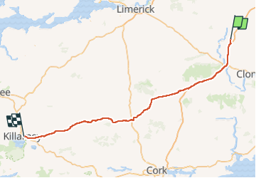
Ruta Coche de 141 km a descubrir en Desconocido, County Tipperary, The Municipal District of Cahir — Cashel. Esta ruta ha sido propuesta por DUPORT16.

Perfil altimétrico

Localización

País:
Ireland
Región :
Desconocido
Departamento/provincia :
County Tipperary
Municipio :
The Municipal District of Cahir — Cashel
Localidad:
Cashel Rural
Salida:(UTM)
575408 ; 5819480 (29U) N.

Excursiones cerca

Excursión Senderismo The Municipal District of Cahir — Cashel - Cahir Scaragh Wood Trail 2 - Photo
Senderismo
johnkeating

Senderismo

Muy fácil
The Municipal District of Cahir — Cashel, Desconocido, County Tipperary, Ireland
5,5 km | 7,4 km-effort
1h 15min
Excursión Senderismo The Municipal District of Cahir — Cashel - Cahir Scaragh Wood Trail 1 - Photo
Senderismo
johnkeating

Senderismo

Muy fácil
The Municipal District of Cahir — Cashel, Desconocido, County Tipperary, Ireland
4,6 km | 5,9 km-effort
1h 0min
Excursión Senderismo The Municipal District of Cahir — Cashel - Cahir Scaragh Wood Trail 3 - Photo
Senderismo
johnkeating

Senderismo

Muy fácil
The Municipal District of Cahir — Cashel, Desconocido, County Tipperary, Ireland
6,4 km | 9,4 km-effort
1h 35min
Excursión Senderismo The Municipal District of Cahir — Cashel - Galtees - Lake Muskry Circuit - Photo
Senderismo
johnkeating

Senderismo

Muy fácil
The Municipal District of Cahir — Cashel, Desconocido, County Tipperary, Ireland
10,1 km | 18,2 km-effort
3h 10min
No
Excursión Carrera The Municipal District of Cahir — Cashel - Bianconi Loop - Photo
Carrera
mlmoroneybb

Carrera

Fácil
The Municipal District of Cahir — Cashel, Desconocido, County Tipperary, Ireland
3,8 km | 5,3 km-effort
2h 0min
Excursión Carrera The Municipal District of Cahir — Cashel - Ballinacourty Loop - Photo
Carrera
mlmoroneybb

Carrera

Medio
The Municipal District of Cahir — Cashel, Desconocido, County Tipperary, Ireland
8,2 km | 10,9 km-effort
2h 0min
Excursión Carrera The Municipal District of Cahir — Cashel - The Millenium Stone Loop - Photo
Carrera
mlmoroneybb

Carrera

Medio
The Municipal District of Cahir — Cashel, Desconocido, County Tipperary, Ireland
9,4 km | 12,4 km-effort
2h 0min
Excursión Senderismo The Municipal District of Cahir — Cashel - Slievenamuck Walking Marathon Sunday March 24th 2013 - Photo
Senderismo
mlmoroneybb

Senderismo

Difícil
The Municipal District of Cahir — Cashel, Desconocido, County Tipperary, Ireland
42 km | 56 km-effort
11h 36min
No
Excursión Senderismo The Municipal District of Cahir — Cashel - Galtee Walking Club Marathon - Photo
Senderismo
mlmoroneybb

Senderismo

Difícil
The Municipal District of Cahir — Cashel, Desconocido, County Tipperary, Ireland
41 km | 54 km-effort
11h 22min


Cerrar
Mis suscripciones